
Finding Addresses Along Bowling Green Streets
A Bowling Green street search is strongest when it follows the property record chain, rather than treating an address as a household list. The Wood County Treasurer confirms that its property tools accept a name, address, or parcel. For an address search, its help recommends the minimum house number and street name, leaving off the street type if needed. The returned Parcel ID is the hinge between the street location, tax account, and Recorder research. Owner and owner-address fields are property-record fields. They do not establish that every person at an address lives there.
- Search the address through the Wood County Treasurer help route or the Auditor-linked property search. Save the Parcel ID, situs address, owner-of-record field, and legal-description clues.
- Locate that parcel in the county GIS context. Note road, parcel, and corporate-limit information, then treat adjoining parcels as separate records to check individually.
- Use the Parcel ID, subdivision with lot and block, tract data, or party name in the Recorder’s AVA index. Do not enter the street address there because that public search mode is disabled.
- Read the index result before requesting a deed or other instrument. Compare its legal description to the parcel record, then record the document number or book and page for the next step.
- For an earlier household clue, inspect a dated local directory, phone book, newspaper, or map source. A volume must be checked on its own terms, because a reverse directory has not been verified for every Bowling Green year.
That sequence keeps local address research focused on documented evidence. It also separates title, map, tax, and historical-directory questions that use different keys.
Bowling Green Parcel Records by Address
The Wood County Auditor real-estate page directs users to Beacon, while the Treasurer supplies the documented name, address, and parcel routes. County offices can also answer questions when a vendor screen does not load. The Auditor is at One Courthouse Square, second floor, with 419-354-9150. The Treasurer is at One Courthouse Square, 419-354-9130, Monday through Friday from 8:30 a.m. to 4:30 p.m. Those are the appropriate fallbacks for an address that needs clarification.
Beacon’s live form was blocked during research. Its exact required fields, advanced filters, result limits, and card tabs were not verified, so this Bowling Green property-by-address reference does not assign it capabilities that were not observed. A printed county map example does document the kinds of parcel context that may appear: Parcel ID, section/township/range, property address, alternate ID, class, acreage, owner, owner address, district, tax description, and data dates. The map’s tax description is specifically not for legal documents.
Note: Keep a property address and any owner mailing address as separate fields in your notes, since the county treats them as different kinds of information.
Bowling Green GIS Street Context
Street-by-street work needs a map only for parcel context. The official Wood County Ohio Parcels service establishes a countywide parcels layer, and the Bowling Green GIS hub provides city mapping resources. The county’s published map inventory lists overview, addresses, roads, parcels, and corporate-limit layers. City zoning material says an interactive map can select a parcel to display zoning, with Planning verification available at 419-354-6218.
The sound method is modest: locate a target parcel, note its identifier and visible map context, then run each needed parcel through the Auditor or Treasurer route. Research did not verify a radius control, an adjacent-parcel button, a map export, or a list-all-on-street function in the live Beacon interface. Do not infer any of those controls from a parcel map. A Recorder instrument and legal description remain the title evidence when a map label and a recorded document point in different directions.
AVA Routes for Bowling Green Streets
The Wood County Recorder AVA index is a party and recorded-document index, not a current-address people search. Electronic index data begin in 1980 and are normally delayed about one day from indexing. Its public configuration shows document number, document type, recorded date and time, Party 1, Party 2, and a legal summary. A detail view can also offer such information as book and page, parcel, subdivision, tract, parties, associated documents, and an image action where enabled.
Most important for local address work, AVA does not currently expose compiled address, municipality, reference-number, or quarter-quarter tabs. Parcel and legal-description information from the property record supplies the workable bridge. The active AVA fields below are taken from the documented local configuration.
| AVA field | Form | Required | Local use |
|---|---|---|---|
| Last Name / Business Name | Text | One active criterion | Wildcard party search. |
| First Name | Text | No | Narrows a party result. |
| Start and End Date | Date | No | Use MM/DD/YYYY for a recorded-date range. |
| Document Number | Text | No | Recorder instrument number. |
| Book and Page | Text | No | Historic or cited document location. |
| Subdivision, Lot, Block | Text and autocomplete | No | Legal-description route for a platted parcel. |
| Parcel, Section, Township, Range, Quarter | Text | No | Parcel or tract route; quarter-quarter is disabled. |
The Recorder maintains its land instruments at 1 Court House Square, Bowling Green, 419-354-9140, Monday through Friday from 8:30 a.m. to 4:30 p.m. Its counter can explain the book indexes and copy process when AVA does not answer the address question.
Bowling Green Deed Trails by Parcel
A parcel result gives the starting point for the Recorder chain. In AVA, use a parcel, subdivision, tract, party, document number, book and page, document type, or date. Then inspect the latest transfer instrument and compare its legal description. The person receiving a deed is the grantee. The person conveying it is the grantor. At an earlier transfer, those roles can reverse, so the land description, rather than a repeated name or street number, holds the chain together.
The public electronic route starts in 1980. Older research has separate access channels: the Deed Index runs from 1821 to 1893; Miscellaneous and Lease indexes run from 1821 to 1969; and Geographic and Finance material begins October 7, 1985. The Recorder identifies AmeriScan Documents-On-Demand as the public route for maintained physical index books, while its counter retains the underlying records. Laredo Anywhere is an account-based professional image route. Recorder copies cost $2 per page and require an instrument number or book and page.
The difference between the electronic and historic index eras is a useful Bowling Green records fact. It means an address trail may shift from AVA to book-index browsing and counter help, rather than ending when the online index reaches its start date.
Plans Along Bowling Green Streets
Plans and permits can date work on a property or corridor, but they are not an occupancy directory. City Planning accepts zoning permit applications for physical projects, while Wood County Building Inspection provides building-permit and inquiry channels. For a specific record, use an address, project name, file number, or time period in a focused request under the Ohio Public Records Act, Ohio Revised Code §149.43. No official general public Bowling Green code-case search was established in the research.
The following Wood County Building Inspection inquiry view is the assigned source image for this route.

Use its inquiry channel to identify a concrete building record, then verify the parcel and project details with the responsible office before drawing a conclusion about an address.
The City’s engineering plan index is another address-corridor resource. It holds 45,255 documents and supports OCR Text operators, Project Name lookup, and document-table choices such as streets, subdivisions, plats, water plans, surveys, and site plans. Results show Plan Set, File Number, Project Name, TIFF or PNG view/download, table, project date, OCR text, and comments.
The assigned Bowling Green engineering plan index image shows that project-oriented route.
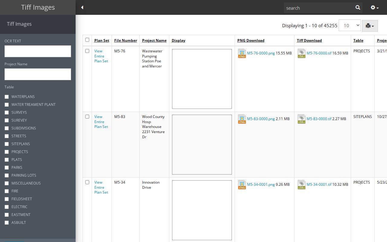
It can add a project date or file reference to a street history, but it does not turn plan records into a list of residents.
Note: Preserve the plan-set and file numbers with the address so an office can identify the exact record later.
Bowling Green Street Record Sources
Each address-keyed source answers a narrower question. Combining them is useful only after the parcel and legal-description links have been checked. The coverage below distinguishes property and document evidence from historical household clues.
| Address source | Starting key | What it can establish | Access route |
|---|---|---|---|
| Auditor or Beacon | Address, owner, parcel | Property and tax context, owner of record | Auditor page, vendor route, counter, or phone |
| Treasurer | Name, address, parcel | Tax account and Parcel ID detail | Online help route and county counter |
| County GIS | Map and parcel ID | Parcel geography, roads, and corporate limits | County service or city GIS context |
| Recorder AVA | Party, parcel, subdivision, tract, book/page | Recorded-document trail and legal summary | AVA, historic books, counter, or copy request |
| Planning or Building Inspection | Address, project, file number | Project, plan, permit, or inspection context | Portal or targeted records request |
| Directory or phone-book volume | Named edition and address section | Dated published household clue | Repository-specific inspection |
A street name alone does not make these sources interchangeable. For present property information, begin with the county parcel route. For recorded land evidence, move to AVA or the Recorder counter. For past occupants, use only a dated volume that has been located and inspected.
Bowling Green Address Field Meanings
One Bowling Green building can carry several valid identifiers. Keeping their roles straight prevents a mailing label or tax description from being treated as proof of where a person lives. The Recorder’s legal description is especially important when a parcel splits, combines, or is described later as “now known as.”
- Parcel
- A county property identifier used to connect a mapped property with its tax-account context.
- Situs address
- The physical street location used by the Auditor, Treasurer, and GIS for a property.
- Mailing address
- The address for tax correspondence. It may be a post-office box, business, representative, another property, or a protected substitute address.
- Legal description
- The lot, block, subdivision, or metes-and-bounds land identity used in a Recorder instrument.
- Plat
- A recorded map that identifies a subdivision or lot arrangement and can help reconcile a changed parcel description.
City Planning cautions that combinations can require a deed that reconciles prior descriptions. There is no authoritative source for a citywide Bowling Green street-renumbering year, so an older number should be checked against the parcel, plat, map footprint, and document description instead of forcing a match.
Earlier Bowling Green Street Clues
The historical route belongs to a particular directory, phone book, newspaper, or map, not to a presumed all-years street index. The Wood County District Public Library Local History collection holds Bowling Green city directories and phone books, but has not published a complete online run or verified a criss-cross collection for every year. A criss-cross directory, when confirmed in a specific volume, reverses the usual name-first arrangement by grouping entries around addresses. It can be useful for a dated occupant clue, while still needing support from the actual page.
For location context, the Library of Congress 1915 Bowling Green Sanborn set has 14 public sheets, and WCDPL offers card-authenticated Ohio Sanborn access. Pairing an appropriate map sheet with a directory page or newspaper mention helps explain a building footprint or street setting. The historical collections themselves are treated in the Bowling Green city directory.
Wood County’s record history also explains why sources divide across locations. The county was established in 1820, and BGSU CAC identifies early court, probate, tax, and Recorder material in separate inventories. Modern portal start dates are access cutoffs, not the beginning of the underlying records.
Bowling Green Street Records and Privacy
Address research has firm limits. Parcel and tax material is not a list of renters or household members. Federal Driver’s Privacy Protection Act rules restrict motor-vehicle personal information. Utility customer data is not a public street directory. Ohio also protects certain voter information, and the Secretary of State’s Safe at Home program uses substitute addresses for qualifying participants. A missing or substituted address is a privacy protection, not a gap to work around.
Ohio Revised Code §149.43 provides a route to inspect public records kept by public offices, subject to exemptions. A focused request should identify the government record needed, such as a plan file or recorded instrument, rather than ask an office to create a private-resident list.
Limits of a Bowling Green Street Directory
A Bowling Green street directory can connect a street location to a parcel, a recorded party role, a dated project file, or a historical source. It cannot establish a complete current household, a person’s physical location, a complete voter roster for a street, or private utility and motor-vehicle data. An owner or mailing field proves only the relationship documented in that property record.
When the question becomes a single person rather than an address corridor, use records that fit that narrower purpose and verify dates and jurisdiction. Keep the address search limited to the property and record at issue, and confirm important facts with the office that holds the source.